

By John Haughey
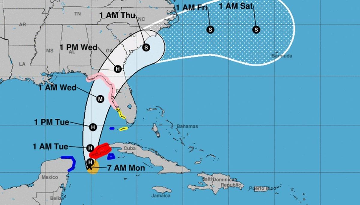
No longer a tropical storm, Idalia has strengthened into a hurricane with maximum sustained winds of 75 mph, as it continues to move toward Florida. Its predicted storm track now stretches up the eastern coastline of the United States to parts of North Carolina.
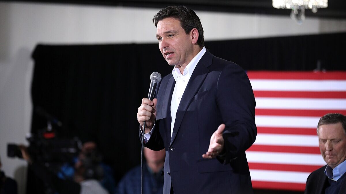
Gov. Ron DeSantis was planning to provide an update at 9 a.m. It can be watched live on The Florida Channel, and on the governor’s pages on Facebook and X, the platform formerly known as Twitter.
Meteorologists with the National Hurricane Center warn “Idalia is expected to intensify into an extremely dangerous hurricane before landfall along the west coast or Big Bend region of Florida.”
Those meteorologists predict Hurricane Idalia will continue to intensify to powerful Category 3 strength until it reaches Florida’s Gulf of Mexico coastline early Wednesday. The current track projects it will slam into the Sunshine State just north of Cedar Key, a low-lying, historic fishing village of about 800.
The town sits at just 10 feet above sea level. If the storm continues on its current track, forecasters have predicted surging seawater will reach close to the top of its streetlight poles.
Floodwaters of 8-12 feet above ground level were expected along between the Chasshowitzka and Aucilla rivers, according to the National Hurricane Center.
Tampa Bay, about 150 miles south of Cedar Key on the state’s Gulf of Mexico coastline, was predicted to experience 4-7 feet of storm surge. Storm surge is the rise of water caused by a storm, beyond the normal and predictable tide change, and is the most dangerous element of a hurricane.
As of nightfall on Aug. 28, more than 5,500 Florida National Guardsmen had been activated, 20,000 linemen from dozens of states were headed south or on-call, search-and-rescue teams had assembled, and evacuations were underway in 15 Gulf Coast counties.

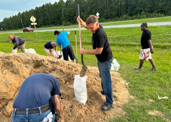
Navy ships have been sent to sea, classes in 38 school districts and 16 universities have been canceled, and airports, businesses, and homes are being shored-up and shuttered.
All that remains is the all-too-familiar wait for 600,000 Floridians warily watching a rapidly intensifying tropical system that wasn’t on any radars three days ago. It is rocketing its way north for a projected Gulf coast landfall between Tampa and Tallahassee in less than 36 hours as a “nasty” Category 3 hurricane.
“It’s definitely coming. It’s going to be a major hurricane. It is going to impact the state of Florida, so please take the proper precautions,” Florida Gov. Ron DeSantis said during a 6 p.m. update in the state’s Emergency Operations Center (EOC) in Tallahassee.
In an interview early Tuesday with The Weather Channel, Florida Division of Emergency Management Director Kevin Guthrie urged residents to heed evacuation orders. But he reassured that the state is well-prepared.
“We’re the best in the business—a well-oiled machine” when it comes to dealing with hurricanes, Mr. Guthrie said.
Don’t Underestimate the Storm Surge
During the evening update on Aug. 28, Mr. DeSantis and Mr. Guthrie emphasized that communities along the Gulf Coast from Tampa to the Panhandle do not need to be in the storm’s path or “cone of uncertainty” to be dramatically affected by its storm surge.
While the updated projection has the system “wobbling” slightly to the west, that doesn’t mean storm surge won’t endanger coastal communities, Mr. Guthrie said, noting the latest modeling actually increases forecasted storm surges “by about a foot, so we’re looking at 4-to-7 feet in some areas, 8 -to-10 feet in others,” and even higher surges elsewhere.
“We are going to see portions of the Gulf Coast that will experience a 12-foot storm surge,” he said. “We also expect heavy rainfall, 4-to-8 inches, with maximum amounts in some areas of as much as 12 inches” with flooding predicted in north-central Florida’s Suwannee River Valley.
Mr. Guthrie said Floridians in the storm’s path must prepare for “isolated storm-generated tornadoes” and “locally damaging wind gusts” to move across the Florida peninsula by midday Aug. 29.
He warned that those who head east from low-lying Gulf coastal areas will avoid the storm surge but not the storm’s rage.
“If you’re moving into inland Florida, you’re going to be the right front portion of that hurricane—that’s what they call the ‘dirty side’ of the storm,” Mr. Guthrie said. “You’re going to experience problems again. You’re going to experience power outages, so please be prepared for those power outages.”
Mr. DeSantis, who has suspended his presidential campaign to lead the state’s emergency response to the storm, was making his fourth hurricane press conference of the day during the 6 p.m. update on Aug. 29. Earlier, he visited with officials in Pinellas and Levy counties and said he’d be checking in with officials elsewhere tomorrow.
He reiterated Mr. Guthrie’s storm surge warning.
“This is life-threatening storm surge. If you’re in coastal, low-lying areas from Tampa through Big Bend, you need to be ready to evacuate to an inland area. Evacuation orders for many of these areas have already been issued. More may be coming throughout the balance of tonight,” he said.

Time Is of the Essence
Mr. DeSantis has declared states of emergency in 46 of Florida’s 67 counties and closed toll booths on state turnpikes in central and north Florida. President Joe Biden declared the 46-county swath to be in a federal state of emergency several hours after the governor left Largo for his 6 p.m. update at the EOC in Tallahassee.
Mr. DeSantis said the state has issued evacuation orders for low-lying areas in Baker, Citrus, Franklin, Fernando, Hillsborough, Jefferson, Levy, Manatee, Marion, Pasco, Pinellas, Sarasota, Taylor, Union, and Volusia counties.
He said a dozen shelters across 13 coastal counties have opened with 11 more set to open tomorrow.
“That’s a place you can go,” the governor said. “You can be safe there, or go to a friend’s house, a family’s house. You can go to hotels and do that. But you do not need to get on the road and try to drive hundreds of miles to get out of any impacts of the storm. That will not be advisable and it’s not necessary. You don’t need to leave the state. You don’t need to drive hundreds of miles. You don’t have to try to outrun the storm.”
Mr. DeSantis cautioned that time is now of the essence for those in the projected path of the storm.
“Clearly, you have time today and, probably, for the better part of tomorrow” to finish preparing for the storm or evacuate inland to higher ground, he said, but waned time is running out with each passing minute, he said. “You are going to start seeing some impacts with winds and some nasty weather Tuesday night and, of course, we’re expecting a landfall to happen sometime on Wednesday.
He said he has activated “the full 5,500 National Guardsmen available” who “have access to a lot of different assets, both on the ground and in the air.” They have also deployed 247 Starlink internet devices.
“We have another 529 Starlinks in central Florida ready to be deployed to impact areas as the need may arise,” he added.
The governor said the Florida Chamber of Commerce is “coordinating resources and they’re having regular calls with private sector partners to make sure that they are prepared. Unfortunately, for a lot of our companies, this isn’t their first rodeo, so they’re ready.”
“More than 20,000 linemen” are ready to respond as part of mutual aid pacts with “more on the way throughout the balance of today and tomorrow,” he noted. “This will be an important effort to get power back on very quickly.”
He said the Florida Division of Emergency Management had received more than 300 requests from cities and counties for mutual aid resources just between noon and 6 p.m. on Aug. 28.
Despite all that, he said, power is going to be knocked out wherever the storm hits.
“I would prepare to be without power. This thing comes in as a Category 3, it’s going to knock over trees, it’s going to knock over power lines. It’s going to cause an interruption in service. So just be prepared for that,” the governor said.
Memories Of Michael, Ian

So, the stage is set—or soon will be—and as ready as it can be for Idalia in whatever form it crashes ashore.
“Obviously, we understand how important it is by staging as many people as we do” to be ready to respond in the storm’s wake,” Mr. DeSantis said. “I have no doubt those folks will get to work immediately once the storm has passed and do a great job restoring [power] but there is not likely a situation where you’re not going to lose power at all if you are in the path of this storm.”
The governor also said the state has bunkered more than 400,000 gallons of fuel “and is ready to deploy any additional assets that are expected over the next few days,” especially for Gulf Coast gas stations.

State officials warned on Aug. 27 of “potentially widespread fuel contamination” affecting up to 29 gas stations serviced by the Port of Tampa.
In a statement, Houston-based Citgo said the cross-contamination of its diesel and regular gasoline was a result of “human error” at its Tampa terminal.
The fuel could damage the engines of those who purchased gas at the affected stations after 10 a.m. on Aug. 26. Since most of the listed stations are in tropical flooding zones likely to see a storm surge and under evacuation protocols, officials fear some people trying to get inland could be left stranded by engine breakdowns.
Florida Agriculture Commissioner Wilton Simpson, the former state Senate president who owns an egg farm in Trilby, northeast of Tampa on the southern traces of Idalia’s projected path, said during an Aug. 28 press conference that the state was inspecting gas stations up and down Florida’s Gulf Coast to determine the extent of the contamination.
Individuals who believe they might have purchased contaminated gas can file a complaint with the state’s Department of Agriculture and Consumer Services (FDACS) at www.FDACS.gov or by calling 1-800-HELP-FLA.
Sen. Rick Scott (R-Fla.), who as Florida’s two-term governor prided himself on his on-scene emergency management during hurricane preparations and recovery, in an Aug,. 28 statement called on residents to “take this storm seriously” and make a plan while they still can.
He said fast-tracking Idalia resembles the “fast intensification” of 2018’s Hurricane Michael, which devastated the Florida Panhandle, in how quickly it formed and how rapidly it is intensifying.
“As we saw with Ian, the storm track can change last minute and Michael showed us that these storms can intensify incredibly fast—from a tropical storm to a deadly Cat 5 in less than three days,” he noted. “You need to be prepared to evacuate even if you’re outside of the cone.”
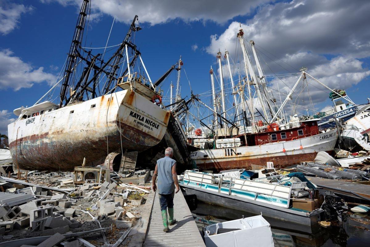
The storm also has many in Southwest Florida fearing it resembles 2022’s Hurricane Ian, a catastrophic Category 5 storm that claimed more than 150 lives, making it the state’s deadliest hurricane since 1935. It was also the state’s costliest storm on record, racking up more than $109 billion in insurance damage claims.
Hurricane Ian, like Cat 4 Hurricane Charley in 2004, was also originally forecast to come ashore north of Tampa Bay along the Nature Coast but, as it barreled through the Florida Straits and into the Gulf of Mexico, was sucked inland by Charlotte Harbor’s shallow 97-degree water, slamming through Fort Myers Beach with a 12-foot storm surge and rocketing up the Peace River to deliver widespread damage across central Florida.
It all comes down to water and when a storm is moving your way, you better already be gone, Mr. Scott said.
“You cannot hide from rising water,” he said, “This storm surge will kill you. If asked by local officials to leave your home, get out!”